Kesugi Ridge
Denali State ParkDescription
If you're coming up here in July or August, and you're looking for a good 3-4 day trail to backpack, this should be your number one choice.
The reason I say this is Denali. The trail basically runs along the side of Kesugi Mountain which makes it a primo location to view North America's largest mountain. Now I want to warn you upfront. Due to the weather conditions Denali creates in itself, you only have a 30% chance of seeing the mountain unobscured by clouds. But if you have good weather, and you have 3-4 days to increase your odds, you will be richly rewarded on your journey.
Even if Denali was not the main attraction, this would still be a great hike. The trail goes through some very interesting and varied terrain, especially beautiful and endless tundra. The guidebooks make this seem like a harder hike than it is. I don't know why. The trail is very obvious and there are numerous cairns showing the way. Yes, there are some heavy duty elevation gains to get to the ridge, but nothing a seasoned backpacker can't handle.
I usually don't do this for the hikes described in this website, but herein is a brief synopsis of the entire trail.
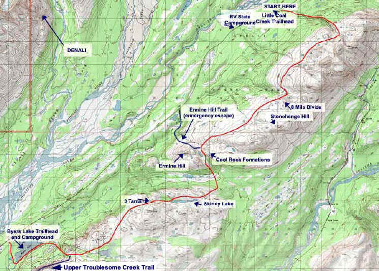
You will definitely want to start at the Little Coal Creek Trailhead. That way, you will avoid about half the elevation gain you'd do at the the Byers Lake trailhead. You won't avoid it entirely as the first 2.5 miles are pretty steep as you work your way up to the ridge (trust me-Byers Lake Trailhead is much worse). Luckily the trail is switch-backed so you'll get some rest periods. As a small comfort, the views of Denali start right away.
Before you know it, you're above treeline and easily fording Little Coal Creek. You'll head over the pass and then your official ridge hike starts. If you're lucky, the Mountain will be visible and you will walk with your head turned right and your jaw dropped down to your chest. I had the best weather and it was so incredible. I couldn't take my eyes off Denali, Mt. Foraker, Eldridge Glacier, and the braided Chulitna River. A really nice touch is the fact that you can not see the Parks Highway below as it is covered by trees.
I kept the first day easy. After seven miles, I went a little lower and found a great private spot, with an incredible view of the Mountain, a flat soft tundra ground for my tent, and a cascading creek that looked like a winding staircase.
The next day I passed 8 mile divide, a huge pass that looked like a tundra football field. You then pass Stonehenge Hill. It, and the surrounding area, are covered in boulders and a white/gray sand. In the back is a beautiful view of the Talkeetna Mountains.
Pretty soon you're back on the ridgeline and heading to the gray dome of Ermine Hill, a very weird and out of place formation. At this point the trail intersects with Ermine Hill Trail where you would take the right turn. You could use this to make this an overnight hike or, as most people, an emergency exit if the weather turns violent.
But if you head down, you'll miss some great scenery, so turn left where you'll drop sharply down into a stunning pass with an island of sand among a lush sea of greenery as well as really cool -should be in a desert- rock formations. This would be a great place to have lunch.
You will then descend down the mountain, where you'll travel through dense, lush forest. This part can be pretty dull, so I would suggest pretending to be Olga Korbut on the balance beam (you'll get this joke when you do this hike). Pretty soon you're heading back up where you'll see Skinny Lake, a very long lake surrounded by serious plant and shrub growth. I had planned on making this my second night but there were no decent campsites, and I kept ascending till I got back above treeline.
I was glad I did! After I went over the last ridge, I saw three lakes. I managed to snag one for my very own where Denali (75% covered in clouds this time) peaked through an opening in the hill in front of the lake. The water was actually warm enough that I could bathe and I even saw 4 teenagers come by and take a swim.
The third and last day, I spent most of the time walking through far as the eye can see tundra dotted here and there with small and medium lakes. It was a really cool experience and made me feel quite small.
Soon you will head down the trail where you will see the intersection for the Troublesome Creek Trail.
Pretty soon, you're below tree line and coming down a steep canyon. You'll head through buggy forest and end up at the Byers Lake Campground where you will either hitchhike back or have a ferried car waiting. Luckily I met some really nice people on the trail (thanks to Chad, Colleen, Jenna, and Sharon! who helped me get back).
It was by far one of the best backpacking experiences of my life, not to mention in Alaska. I urge you to put this on your list.
Summer 2004: I redid this hike and it was still as thrilling and wondrous as the first time. This time I left my truck at Byers Lake late Friday afternoon and hitched to Coal Creek. I just went far enough to get up to the ridge and camped on a spacious area with a stunning view of the mountain. There were ripe blueberries everywhere. I spent 3 more days doing the trail and the weather was perfect. This truly is one of the best trails in Alaska!
Important Information
Understanding topo maps for this hike can get confusing. I found it hard to match where I was to what was on the map as many features look similar. I totally misjudged where I was the first night, and I wasn't the only one. Please view my photo page carefully so you will have visual landmarks of locations. For this hike, the pictures are in order of when I saw them.
As stated above, there are no really good places to camp at Skinny Lake, not to mention the surrounding vegetation. You will have to head back up mountain. Plan accordingly. If you were doing 3 days, I would do first night before Ermine Hill and second night the 3 tarns back up the mountain after Skinny Lake. You do want to stop at the lake for water as there are inadequate sources till you get back at top.
Prepare for bad weather. You are very much exposed on top of this ridge with not many places to buffer you from a fierce storm. Make sure your tent can handle high winds and you have proper clothing. On the other extreme, there are no places to get out of the sun. I wish I had brought sunscreen as I wound up with a nice burn on my face and arms.
The chance for fog is high here. Luckily, you have the cairns. No matter what the weather, trust the cairns. They are spaced about every 50 feet and are only used for the Kesugi Trail. Be safe though, and have at least rudimentary navigational and compass skills.
Pace yourself for the ascent back up from the forest. You will have to climb over many chasms and ridges and it can really wear you out.
Before you descend down to Byers Lake, put some DEET on. It is mosquito hell once you get below treeline. You can stop by the lake once you get off the trail to wash up.
Etc.
If you want to camp the night before, you can do so at Byers Lake. There is also an RV parking lot 1 mile below the Little Coal Creek Trailhead. The view is great but the camping sucks. You are not allowed to camp at the trailhead parking lot.
"Kesugi" is a Tanaina word which translates as "The Ancient One".
A traverse can be made of any length (see below) and/or direction with Kesugi Ridge and the Upper Troublesome Creek Trail.
| Coal Creek | Ermine Hill | Byers Lake | Troublesome | |
|---|---|---|---|---|
| Coal Creek | 17.2 | 27.7 | 36.2 | |
| Ermine Hill | 17.2 | 17.2 | 25.4 | |
| Byers Lake | 27.7 | 17.2 | 15.2 | |
| Troublesome | 36.2 | 25.4 | 15.2 |
There are various companies offering shuttles that can drop you off and pick you up at the various trailheads. Expect to pay $40-$75.
Photos


")


")


")


Finding the Trailhead
Hike Map