Eagle Peak
Chugach State ParkDescription
The namesake peak of the Eagle River Valley, jagged and imposing Eagle Peak penetrates nearly 7,000' above sea level into the Chugach sky. On a day with good visibility, few summits can take you higher and provide a more rewarding challenge without the need for climbing equipment so close to Anchorage. At the summit, you won't believe where your own two feet have taken you as you look far below at Eagle and Symphony Lakes - nearly a vertical mile below!
Only for those that are highly fit, one can climb 6,909' Eagle Peak in a day trip from Anchorage, sleeping in their own bed the night before and night after. Most will want to take two days, making camp in the largely untrodden upper valley of the South Fork of Eagle River. In either case, the route is replete with lung-busting uphills and butt-busting downhills, and more twists and turns than the plot of "The Empire Strikes Back". With cooperative weather, summiting this Chugach Range peak can be a transcendent experience.
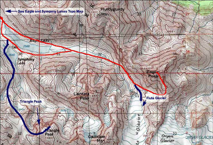
Hike the well-worn trail paralleling the South Fork of the Eagle River five miles to the bushy isthmus of land cleaving Eagle and Symphony Lakes. Here, gazing up the valley above Eagle Lake you will make your first sight of Eagle Peak. Upon ogling the sharp summit reminiscent of the Paramount Pictures logo, my hiking partner Allen & I literally laughed out loud in now understanding the formidable challenge before us.
Follow the thinning path between the lakes to the head of Eagle Lake, and descend slightly to the glacier-braided stream feeding the lake. Continue upstream, hopping across braids at times. At last check, some orange flagging adorned the alders here, suggesting an efficient route. After 3 upstream miles, you will climb and bushwhack to the left of a tall waterfall. You will soon feel partly "walled in" from 6,400' Cantata Peak on the right, and big brother Eagle Peak ahead, and to the left.
A mile or so after the waterfall, Flute Glacier, perhaps the closest glacier to Anchorage in a straight line distance, will come into view. The toe of the glacier is a pleasing rest stop and the end of the road for inexperienced hikers.
To approach the summit, you will want to backtrack from the glacier's snout a few hundred yards, and gain the slope to the east which eventually flattens into a high cirque. Stop at the cirque for a few minutes and listen to the falling rocks regularly tumbling down the south face of Eagle Peak. You are about to ascend into a world of rock. Climb a scree-lined field leading to the base of a gully on the south face. A trickle of a stream spills down the steep rock. The first rock scramble to begin the ascent in earnest is a good test, as the higher climbing gets no more difficult, just as a popular book attests.
A series of gullies, talus, and scree lead to the summit. There is no clear trail - just keep in mind not to stray too far to the left or right, continuing up. If you don't have a GPS, you can gauge your vertical progress by looking to the summit of neighboring Cantata, 500' shorter than Eagle Peak. You may need to use your hands in some places. Expect small route finding mistakes.
A popular book states that the gully splits near the top and that you are to take the right fork. This confused us during our hike and we found success bearing slightly left high in the gully. As you approach the summit, look for a notch in the summit ridge. Aim for the notch. Once gained, it will be obvious to head to the right to gain the summit proper!
From this high summit, you can take in the great magnitude of the Eagle River Valley and it's tributaries. Look south onto the twin rivers of ice known as Organ and Flute Glaciers; and jagged, craggy neighbors Organ Mountain and Cantata Peak. Eagle and Symphony Lakes will appear tiny - about one vertical mile below your feet! Looking far to the east, the breadth of countless snowy, glacier-clad peaks and numerous white and blue glaciers lend perspective on how the local civilization only indents one corner of vast, remote, and wonderful Chugach State Park.
On August 15, 2004, Allen and I were only the 9th and 10th persons to sign the summit register - stashed tightly in a summit cairn - for the year. You will find two pleasant surprises when you descend: numerous routes become visible that weren't so clear on the ascent, and the safest route among them may be chosen; and scree becomes your friend as it cushions you and eases your body on the descent.
This "walk-up" was my most pleasing Chugach summit ascent - besting Bold Peak. To those whom are up to the challenge and with the right weather, Eagle Peak can likely be your greatest day in the Chugach.
Important Information
In wet weather, do not attempt to ascend the peak as wet rocks make scrambling sections precarious. If you attempt to climb Eagle Peak in one day, a headlamp is recommended, but may not be needed. Whether attempting Eagle Peak in one day or two, you must be fit, relatively experienced, have a few ounces of indefatigability, and be willing to do some route finding.
Etc.
Mini-binoculars might help you spot Dall Sheep on Cantata Peak and elsewhere, clinging to precipitously steep slopes. As sacrilegious as it sounds, "scratchy" cell phone reception exists at the Eagle Peak summit...and as jaw-dropping as the summit views are, you may want to phone someone!
Finding the Trailhead
Take the Glenn Highway to the Eagle River Loop / Hiland Road exit. Turn right off the highway, and then another right onto Hiland Road, which you will follow for several miles, nearly all the way to the end. Turn right on South Creek Road, then another right on West Creek Drive. The parking area for the trailhead will be on your left. This is a very popular trail, and on a busy summer weekend (especially if the weather is nice), expect to find cars overflowing the parking lot and lined all along the side of the road.
Photos


Finding the Trailhead
Hike Map