Eagle River
Chugach State ParkDescription
During the off season, I really like this place because you can walk along the braided riverbed and camp out on it. When there’s been a lot of snow, it is a very accessible way to the backcountry. It’s also a great fall backpacking trip for the golden leafed aspen in the area.
However, during the season, I have a love/hate relationship with this place. On the good side, there are some terrific sights once you get to the river. Go at least six miles from the trailhead because that's when the scenery starts to get good. Another plus is the always good chance for wildlife viewing including bears, eagles, dall sheep, and a mess load of moose. If you can make it to the end, that's the best part; nice and open with a glacier and glacial lake nestled in the mountains.
The following was added 4/20/03:
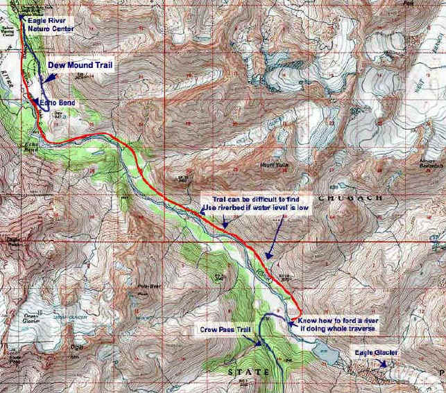
I just got back from 3 days of backpacking and I am definitely on the love side tonight. Because of our unseasonably warm winter this year, the river was quite low. Subsequently, I was able to easily ford the river the 20-30 times necessary to beeline it to the end. It was never more than a foot deep. At the end of the trail (where the Crow Pass Trail starts), I set my tent up with a spectacular view of Eagle Glacier.
It was a sunny 3 days and I was able to spend all morning the second day exploring around the glacier. I was all set to do this the last time I visited in March of 2002, but I woke up to a snowstorm and had to hightail it out of there (see picture). While the glacier is a cool sight (pardon the pun), the chasm, lake, and surrounding landscape is incredible. You could spend an entire day getting to know it.
So my new review is: If you're going to do this trail, commit and go to the end. You'll be glad you did.
Be warned: looking at the glacier from a distance gives the illusion that the glacier is hanging near the moraine. There is a huge expanse between them. Give yourself an hour to negotiate the rough landscape to get to the glacier proper. Be very careful and plan ahead. The smartest way seems to be to ridgeline it on the North side.
On the down side, there are too many people and very little chance for solitude. Another minus is the really gross sections of the trail. Sometimes you’re bogged down in mud and towards the end, finding the trail can be quite difficult. The designated campsites are underneath the canopy so I usually wind up camping on the riverbed. I'll probably get a lot of flak for this because there's a really nice nature center at the trailhead and there are a lot of dedicated people who help out at the place, so to them, I apologize. I have seen volunteers working on the trail and hopefully they'll have it back in shape soon. But for visitors, I wouldn't put this on top of my list for a backpack trip. You can do better. For people who live here, save it for the off season when you'll need it more.
A very popular hike is to combine this with Crow Pass where a car has been dropped off at the other end before the journey. The smart move is to start at the Crow Pass side, as the elevation would be mostly downhill if you do.
Starting at the Nature Center are several short day hikes (perfect for kids). There is also a yurt (a circular dwelling mainly used in Mongolia) and a cabin on the trail for rent. This is a great idea for families in the winter; less than 3 miles from the trailhead and the firewood is cut and ready to burn. Go to the website for details and availability.
Important Information
At about mile 7 is where the trail can get confusing. Take your time and expect to backtrack. If it gets really confusing you may want to consider fording the small tributaries till you see an obviously marked part of the trail. If you do decide to cross sections of the river, know how to ford a river safely. Except for the summer, be aware that there are hunters in the area.
If you're going to camp on the riverbed, use some common sense on where you set up so that if heavy rains come, you won't be swept away.
There's a good chance that you will see bears here. Make sure you are educated about bear safety.
If you do the entire traverse with Crow Pass, be aware that midway you will have to ford the river where it is waist high and chilly (it may be lower or higher depending on when you do the hike and the previous rainfall).
The following was added May 12, 2008:
Just got back from a weekend where I camped right on the shore of the lake. There's been a lot of work on the last 3 miles of trail that was wiped out in the flood of 2000 (2001?). Some parts are very eroded though and at one place where a roughshod ladder is placed to get down a boulder, I had to veer off since my dog couldn't negotiate it.
I always wanted to camp by the lake and you couldn't as for a better view (go to photos). However, there isn't one spot that isn't covered by glacier gravel so bring a thick sleeping mat. You could camp on the other side by the glacier where it is sandy but you would make a big sacrifice on view. The area is covered with lot's of bone dead wood and I never walked more that 6 feet from my site to gather firewood.
The following was added June, 18, 2008:
There is a new shuttle service for transportation to and from the trailheads: Girdwood Shuttle, Tours and Transportation.
Etc.
Parking at the Nature Center is $5 a day (they won't charge you for 2 days if you're doing an overnighter). Your Chugach State Park pass is not valid here. If you're backpacking for several days, you can park in the lower section for $5/3 days.
If you have the time, it's worth it to go in and check out the center.
For great information on winter camping, I recommend the book Winter Camping, 2nd Edition by Stephen Gorman (Appalachian Mountain Club Books) 1999.
The best way to hike this in the winter is to buy a cheap plastic sled and carry your stuff on it. For details about how I built mine, go here.
For the advanced backpacker:
Chris Harper has a route from Eagle Lake to Eagle River that uses part of the trail above that you may be interested in: link here.
Photos


Finding the Trailhead
Hike Map