Grace Ridge
Kachemak State ParkDescription
On a sunny or high-overcast day, this hike provides wonderful views of the mountains, glaciers, bays, fjords and islands in this area of Kachemak Bay State Park.
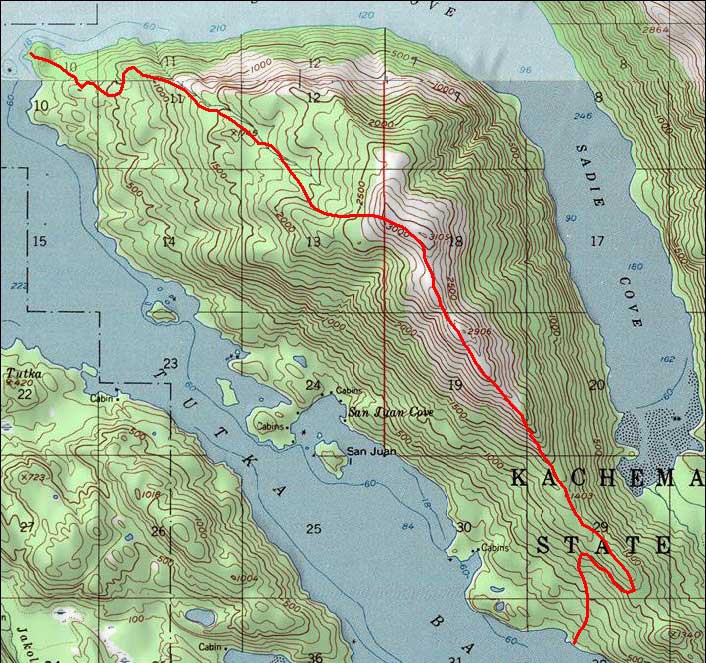
The trail starts at sea level, at a beach head known as Kayak Beach. The moderate trail through 3 miles of boreal rain forest climbs 1800 vertical feet to a knob above tree line. This location provides an awesome 360-degree view. People with little wilderness experience and/or moderate physical conditioning can get safely to this point. Most hikes end happily here. Continuing requires good physical condition and wilderness experience.
Beyond this point, there is no defined trail and overland alpine hiking begins. Depending on the route chosen, the climb to the top of Grace Ridge can be steep, sometimes dangerous. With prudent route selection, there are several safe ways to the summit. The summit is a flat, barren, rocky landscape at 3100-feet elevation.
The trail follows barren rocky ridges for a mile or two before the descent to sea level begins. The descent to sea level through the forest is steeper on this side.
The trail ends at a cove off of Tutka Bay known as South Grace Ridge trail head.
Since the trail starts and ends at different locations on the ocean, most hikers do not travel the entire trail. Most hikers go from one of the sea-level trail heads, up, and back to the start.
Important Information
Please note that the trail is accessible only by water and it starts and ends at different locations on the ocean. It is popular with kayakers. Several water taxis will drop-off and pick-up. A few own-boaters access the trail.
Winter storms often topple large spruce trees that can be difficult to cross. Each spring, a group of volunteers, with chainsaws, clears the trail. I wait until after the trail clearing.
Black bears are prevalent. They tend to run away and are usually afraid of people. I have had several bear encounters but have never had to use my bear spray. The most common sighting is the rear end of a bear running away.
If clouds or fog are possible above tree line, don't go. If you go in fog, be sure to use a GPS to mark the trail where it exits/enters tree line. Otherwise, you won't be able to find the trail when you descend from alpine to forest.
A portion of the trail follows alongside a clear cold cascading stream. After a refreshing drink from the stream, you will climb up to the snow fields where the stream originates. The amount of marmot doodoo on the snow fields may make you regret that refreshing cold drink of water.
Etc.
There are yurts available for rent at each end of the trail.
The Kayak Beach trailhead has nice scenic tent camping.
Photos


Hike Map