Grewingk Valley
Kachemak State ParkDescription
*NOTE: the first time I did this hike, in 1999, it was a disaster. Older and wiser, I redid this hike July 2004. Subsequently, this hike has been rewritten to reflect the new information.*
The first time I ever did this hike (1999 – before I moved here) it was a total disaster. We went in late September so the temps were pretty cool. It had been steadily raining all day and just as we were about to set up the tent, it really started to pour and all our stuff got wet. We spent the night huddled and shivering in the tent while a stiff and fierce wind blew all night and the deluge continued unabated. What we didn't know at the time was that we were in the worst storm the area had seen in over 10 years! Our water taxi wasn’t going to pick us up for 2 more days! We had both been both very uneducated about hypothermia and had bought the wrong clothes (most of which were wet). I was shivering all night. I wasn’t worried that I was going to die but I felt there was a good chance I was heading to the emergency room with a bad case of exposure. The next morning, we had to pack up in the rain. Our goal was to get to a cabin 20 miles away and wait out the next few days. Luckily, we met up with a day hiker who had a boat. We met up at the trailhead and she radioed for the water taxi.
That trip has always haunted me and since then, I’ve done the work to educate myself on hypothermia and to make sure I have the right clothes for no matter what happens up here. In July of 2004, I decided to redo this trip, what I affectionately called my “back in the saddle hike”. Since I was a bit stressed in ’99 and the rain made for inferior views, the rest of the description will be as if I had done the hike for the very first time in ’04.
The great thing about this area is the wide variety of terrain. You can take the boat over and do some day hiking but if you can, I would suggest either a backpacking traverse from Halibut Cove to Humpty Creek (see below for why I suggest this direction) or a loop back to the tram returning to Halibut Cove. Depending on how long you’re out there, you can explore some of the side trails (see topo). If you just want to do a day hike, make it a long one and head to Grewingk Glacier. Be aware that the water taxi pickup/drop off times are mostly dependent on high tides so you may be out there for a while. For a quick little jaunt, take the Glacier Spit Trailhead to the Glacier Lake Trail and have the taxi pick you up at the Saddle Trailhead.
You can start the traverse/loop at either Saddle Trail or Glacier Spit. Saddle has a ½ mile of elevation gain but Glacier Spit is longer. You will head through a flat valley with a nice view of the glacier. Eventually you will come to Grewingk River and you will use a tram to cross over it. This is a serious upper body work out, especially for me when I did it as I was traveling alone and had to haul a pack, myself, and an extremely agitated dog who was not happy being in this strange contraption above a raging river.
Once over the river, you will head up and over Foehn Ridge, your first foray into a rain forest on this trip. Most of the trail is overgrown and you’ll need to tread carefully but you’ll get great views of Grewingk Valley, Lake, and Glacier and it’ll be over sooner than you think
Then it’s back to the flat bottom where you’ll head in and out of spruce and willow eventually ending at the lake. If you’re day hiking, head left to get to the glacier. If camping, head to the lake. There aren’t a lot of great places as the beach is very rocky so bring extra mats to be more comfortable. There are also some sites beyond the beach but I’ll sacrifice for a view and would rather be on the shore.
The lake is very silty with icebergs floating around from the calving glacier. On the other side of the lake near the glacial moraine is a huge rock in which there are many seagulls hanging out. It can be very noisy but I didn’t find it too disturbing. There is a lot of wood to make a fire. While I was there, 2 black bears came to the lake to drink.
The next day, I headed to the glacier. It’s a nice hike that heads up toward the left end of the glacier. Just before the glacier, there is a clear water tarn with a nice beach. I wish I had known about it, as it would have been a better campsite (albeit a little chilly due to wind coming off the glacier). The glacier is really cool. Look for a cairn where the rocky ledge is to head towards the glacial terminus at the lake. Unfortunately it was too steep for my dog to climb up and I didn’t want to risk her freaking out by leaving her behind. You can easily spend all day exploring the glacier and I urge you to plan your trip this way.
After my day hike, I headed back to camp, packed up and made my way up the Emerald Lake Trail. This was arguably the worst part of the trip for me as it is very steep, very overgrown, and very humid as you are in rain forest. Even though it was two miles, it felt like forever and I was really glad when I finally got to Emerald Lake.
The lake is really beautiful and luckily, I had it all to myself (in fact, I never saw anyone from the time I was dropped off till I was almost at the Humpy Creek Trailhead). Again there aren’t a lot of good sites. Heading down to the shore there is a trail on the left that leads to a wood platform and a trail to the right that leads to a metal bear box (Yayyy!! No having to hang the food from a tree) and a fire pit area. Camp on the beach if you can, as the view is just so much nicer. The beach is a lot more comfortable than Grewingk Lake as well. I didn’t see any bears here but there was one rustling in the forest very near me.
The next day, I headed away from the lake and over the mountain. Again the trail was overgrown, but it was over quickly. Eventually you will see an orange pole sticking up from a cairn, which signifies you are heading into Portluck Plateau. This is a relatively flat, tundra area with gorgeous views of Kachemak Bay, Homer Spit, Grewingk Valley and the Cook Inlet. You’ll cross over this Plateau and then start heading down the mountain into Humpy Creek. Again, you’ll head into very overgrown vegetation. As you head down, you will see why you should do this traverse starting from Halibut Cove. This is very steep and endless and since it’s a rain forest, humid as well. The first time I did this trail, I went up it and by the time we got to the Plateau, I was sweat soaked and dieing!
As you go down, the Emerald Lake trail becomes the Humpy Creek Trail. When you finally get to the bottom (where I saw a black bear quickly head into the woods), do not head to the shore, rather stay parallel with the mountain and follow the orange triangle markers to the Trailhead sign (a cabin sits in the back woods from it). Wait for the taxi here! The tide is very fast and you will soon be surrounded by water if you wait at the shoreline. If you like, continue on this trail and you will go around the mountain until you eventually get back to the tram. I had the taxi pick me up at Humpy Creek and I really wished I had told him to pick me up the next day back again at Saddle Trail so I could have more time out there.
If you’re in the Humpty Creek area in August and early September, you will be greeted with an awesome site of people, bears, and eagles vying for the many salmon that run up the creek. When I went the first time, my friend and I saw 30 eagles!
If you’re looking for a real Alaska backpacking experience but the thought of no established trails worries you (as in Denali and Wrangell National Parks), this is the perfect place to get all the types of scenery and experience you can in one place.
Important Information
Do not use the guidebook, Hiking Alaska: A Falcon Guide (By Dean Littlepage, Falcon Publishing, Inc. 1997). It is outdated on the new trails that have been added since publication. I haven't seen the recently published 2nd edition which might be better.
As stated above, the park is only accessible by water taxi. Due to the extremes in tides in the area, the "driver" will determine when he can drop and pick you up depending on where and when you want to go.
Remember to be careful when at Humpy Creek. The tide comes in very fast and you and/or your gear can become very soaked very fast.
There is a very good chance you will encounter bears here. Know and practice bear safety. Be careful on the lush, overgrown trails where you can not see ahead very well. Remember to make noise by either talking with your hike mates, singing or shouting "Hey Bear!” at regular intervals.
Be careful around the glacier. There are lots of loose rock and it is very easy to slip. I definitely recommend a walking stick. Do not climb on the glacier! Snow could be hiding a deep crevasse and if you fall in, it was nice knowing you.
Definitely filter or boil the water in Grewingk Lake. There are a lot of birds making deposits and there is not much flow to the lake.
There is no water until you get to the tram.
The Tram: the tram holds a maximum of 2 people with packs. Be prepared for sore arms; using the tram is a real upper body work out. Go to the official website (info is under the Grewingk Glacier Trail description) to be familiar with its operation. You may want to call ahead as well to make sure it's in operation. Bring gloves! and have them handy. They'll make a big difference.
About 1/3 of the trail is overgrown. Be careful of devils club and cow parsnip. Wear long pants and if you're a short person, consider a light long shirt.
Take a mental picture of the trail as you come out onto Grewingk Lake. It is not obvious when you need to get back on it.
Be prepared that if adverse weather conditions occur, the driver may not be able to pick you up at the designated time. You may even have to stay over one more night. Make sure you pack extra food, etc.
Due to my experience on this trail please learn all you can about hypothermia.
The Lagoon Trail connects the northern part of the park with the southern but there is an extremely deep, cold and fierce glacial river to cross. Plan your trip in either section but not both. If you feel confident you can do this, educate yourself about fording rivers.
It demands repeating: You are far from help. Be careful and be prepared!
Etc.
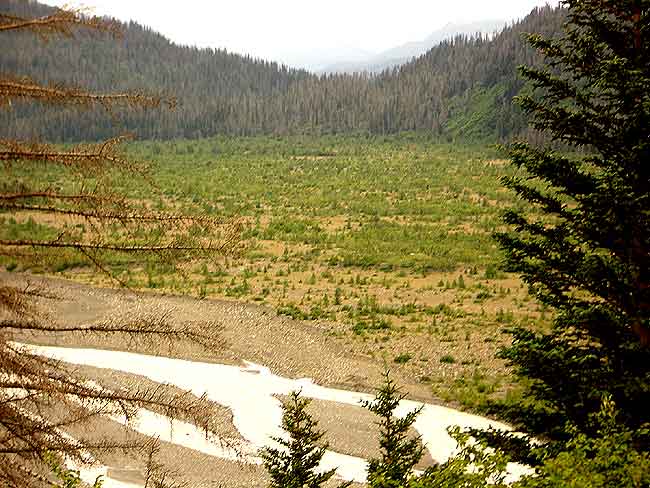
You'll notice a lot of standing dead spruce all over Southcentral Alaska but especially here. Over the past 20 years, there has been a major infestation of spruce bark beetle.
If you'd like to educate yourself about glaciers and their awesome power, please visit All About Glaciers, a great introductory website.
The City of Homer is one of the best towns in Alaska. I absolutely love this place. I would highly recommend spending a few days here before or after your backpacking trip. If fishing, whale and other marine life watching, or road tripping is on your itinerary, make Homer the place to do it. For more info, link here.
Photos


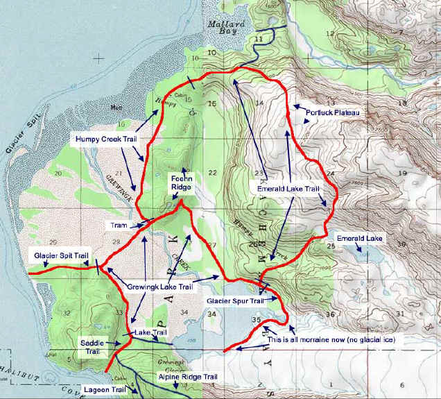
Hike Map