Hanging Valley
Chugach State ParkDescription
I had known about this hike for about 3 years before I ventured over from my usual route to Eagle and Symphony Lakes. The lakes are such a great destination and it seemed like a waste to sidetrack to what I thought was a basic, seen it before, glacial valley. But since I started this site, I decided to do it so I could add to the number of hikes already online.
Well! I'm glad I started this website because I would have never discovered this really cool valley if I didn't.
It's a small valley but it has quite a few gems. The entire place is so ripe for exploring. The valley is dominated by Hurdygurdy, a mountain that looks to be gouged out by 2 different glaciers causing it to seem twisted and spiraled. One of the glaciers has left an incredible lake set on top of a lush tundra plateau in which a waterfall flows down to the valley below. This is where I set my camp up the first time I visited; an ideal spot.
The moraine is really cool. What looks from a distance to be a perfect circular mound is a hodgepodge of deep crags and gouges. My guess is that this glacier receded and advanced repeatedly in its waning years - its last gasping breath.
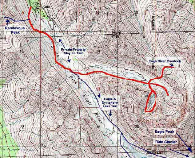
On the other side of the valley is the trail that leads to the saddle of Harp Mountain and to the Eagle River Overlook. I was all set to do it the next morning but a dense fog rolled in and made the trip superfluous. The next time I go, I will definitely make the trek.
The valley itself is lush without being overgrown. There are plenty of great spots as well as numerous small tarns to camp by. The creek bisects the middle of the valley. For real privacy, head to the very back of the valley where you will find two tarns, one above the other, with a waterfall connecting the two. (note: the upper lake dried out by mid summer July 11, 2004)
My advice: set up camp, bring a day pack and spend the rest of the day exploring.
Important Information
Until you get to the bridge down in the valley, you are on private property. Stay on the trail and respect the owners.
Be aware that the trail into the valley can fade away in places as you crest the ridge after the bridge. At the trail intersection shortly after, take the one that heads straight up. You should be heading toward the next ridge and not the creek. Once you get over this ridge, it's easy to spot the trail slicing through the valley.
At the plateau where the nameless lake is, use the left side of the moraine to access the top. The sides are quite steep with scree. I had to slowly slide down on my butt on my return.
The mountains in this valley look very inviting to climb but are quite steep when you actually do. Be careful and don't bite off more than you can chew.
If traveling with your pooch, keep a jug of water and a bowl in your vehicle. There are no water sources (except boggy stuff), from the bridge to the trailhead. If it's a hot day, your dog will thank you.
Finding the Trailhead
Take the Glenn Highway to the Eagle River Loop / Hiland Road exit. Turn right off the highway, and then another right onto Hiland Road, which you will follow for several miles, nearly all the way to the end. Turn right on South Creek Road, then another right on West Creek Drive. The parking area for the trailhead will be on your left. This is a very popular trail, and on a busy summer weekend (especially if the weather is nice), expect to find cars overflowing the parking lot and lined all along the side of the road.
Photos


Finding the Trailhead
Hike Map