Lost Lake Backcountry
Chugach National ForestDescription
I’ve been trying for the last few years to check out the area west of the lake. The guidebooks mention that it is actually possible to hike to Coopers Landing from here but I was more interested in checking out the glacier visible from Lost Lake since it seemed so easy to get to. Well! I finally had a full day to go exploring and this is a magical place.
If you can, I urge you to spend an extra day at Lost Lake to explore the first glacier and its moraines, as well as the tarn and surrounding tundra. There are actually 2 more glaciers after the first one plus a whole bunch further down this valley. If you’re looking for solitude away from the other campers, head to the tarn and camp on the north side. With a beautiful aquamarine lake, a 3-glacier view, the endless patches of fireweed (late summer) and endless vistas, it doesn’t get any better than this!
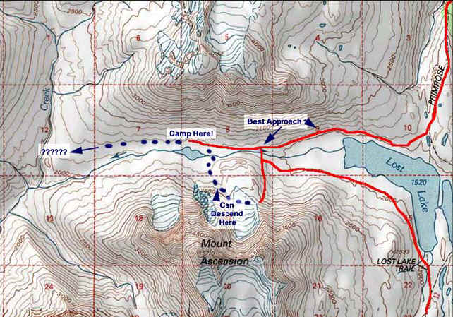
The best way to get into this area is to come in from the North side of Lost Lake. Most of the time, there will be a small trail. Once past the willow, either head to the tarn and set up camp, or officially start your hike to the glacier by fording the stream at the best opportunity.
The 3 glaciers are definitely receding and will probably be gone within the next decade. They are quite small but very interesting as half of the ice is underneath broken rock and scree. There was much meltwater coming off of them. The leftover moraines are quite impressive and there is a small muddy tarn in between them. Conceivably, you can hike to the other 2 glaciers but it commands caution and the sights wouldn’t be any different than the easily more traversable 1st glacier. Check out where the meltwater flows into the main stream that goes into Lost Lake, as it is quite a contrast with the non-silty water flowing from the tarn (see photos).
I would love to do a 3-day walkabout in this area and head out the same way I came in. If I had someone willing to help with an extra vehicle, I would love to attempt the journey to Cooper’s Landing.
Important Information:
Be very careful walking on the first glacier. The broken rocks definitely help with traction but it’s not a guarantee you won’t slip. Best to bring a walking stick to be safe. Do not go near the crevasses!
From Lost Lake, it seems reasonable to head up the first visible ridge and diagonal it up. What you don’t see are the several other ridges between that one and the actual glacier. Better to come from the other side, ford the stream after the willow and head up the doable ridge (see topo map). You can bushwhack the willow but be aware that there are endless little streams and creeks that you will have to ford.
Photos


Finding the Trailhead
Hike Map