Mt. Gordon Lyons
Chugach State ParkDescription
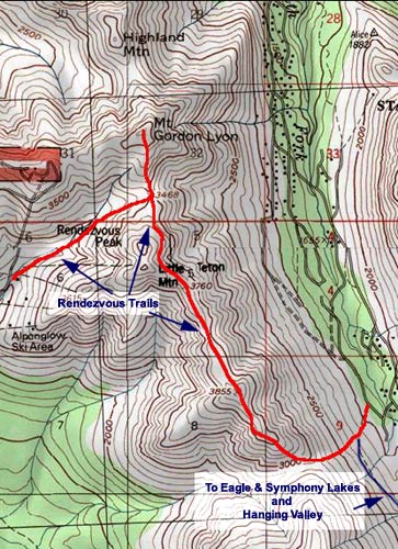
This is a great hike for after work, especially for someone living on the east side, or for someone who just got in to town and wants a quick overview. Most people hiking in the Arctic Valley head to Rendezvous Peak so you'll also get a little more solitude heading left instead of right when you get to the saddle.
Once you easily get to the saddle (from Arctic Valley Rd.), and a quick hop to the peak, you will have an outstanding 360° view. Herein, starting north: Denali and the Alaska Range (on a clear day) Knik Arm, an old Military site, Highland Mtn, the town of Eagle River, the north fork of the river, its surrounding peaks (Magnificent, Baldy, Black Tail Rocks, Harp, Vista & Roundtop), Eagle Glacier, the south fork of Eagle River with Eagle and Symphony Lakes in the distance, Rendezvous Peak, Ship Creek and Indian Valley, Anchorage, Turnagain Arm, and the Cook Inlet.
Sign the register in the plastic tube when you get to the top. If you're very careful, you can head down to Highland Mountain.
Truly, this is a really good view, and with it so easy to get to, residents should put it on their one of these days list.
Important Information
Bring water; no sources after a small creek.
Do not go near the military installation! It is a restricted area and you can be fined if caught. Here's more information about hiking on or near military lands.
Finding the Trailhead
The trailhead is at the end of Arctic Valley Road, adjacent to the Alpenglow Ski Area. Take the Glenn Highway to the Arctic Valley exit and follow the switch-backing road for about seven miles to the parking area run by the Anchorage Ski Club. Note that there is a $5 parking fee at Arctic Valley. Your State Park Pass is not valid here.
Photos


Finding the Trailhead
Hike Map