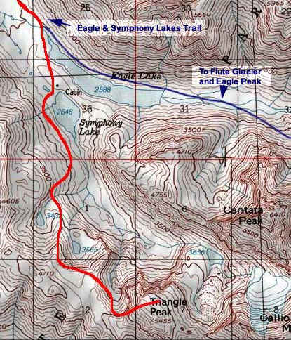
Triangle Peak
Chugach State ParkDescription
Triangle peak is located at the head of the Symphony Lake valley, and to access the route described in "50 Hikes" you will need to use the Eagle / Symphony Lake Trail, which is 6 miles already. We did this as a backpacking trip up to Symphony Lake and we trucked along the trail to the lake from the trailhead making it in just under 3 hours. We set up camp, took in the scenery, and looked at what we were up against.
The next day, after a day of absolute sun - we had low clouds over the entire Eagle / Symphony basin. We headed out to the Symphony Lake input stream and hiked maybe 3/4 of a mile up this valley. Since the time of this writing there has been a massive, I mean absolutely massive, huge beaver dam on the input stream, making crossing difficult and flooding a lot of what was crossable and narrow in years past. Trying to find a dry-foot route was challenging, but possible with a lot of jumping. We missed the gold lichen speckled slope as the book describes, but met up with it later. The trail is pretty well worn, and there are some cairns - but the area where the streams pour out of the tarns is pretty obvious.
From there, the ridge in which you need to climb is pretty straightforward, although we had some difficulty with no map and low clouds. We arrived at the lower tarn in about an hour's time from Symphony. It was difficult to locate the upper tan because of the fog, and it is not as easy as the book makes it sound. Nonetheless we headed up the ridge, to point 4710'. There is a path along the talus-like slopes about 500' vertical below the summit, which puts out at Triangle Pass.
The last bit of the route takes you up a classic Chugach mixture of boulders, talus, some scree, and a tiny bit of scrambling. The mix isn't so hard, just pretty tiring - especially doing small traverses along where it is very loose.
The summit is "plateau-ish" and gently rolls down, except for the north face. There is a register at the top, but we don't know what they look like, and didn't look too hard for it. The views are great - you definitely feel like you are up there with the big ones. With Cantata (6410'), Calliope (6810'), and Concerto (5505') across the valley, it is definitely a site worth the trek - especially with the fog we encountered - it only let the tips of the higher mountains poke out.
Following the trail back, we found the upper tarn, as the fog burnt off, and all in all it took us about 6 hours, with a good number of breaks and summit time.
Important Information
If you are camping, it's a better idea to camp at Symphony Lake because if you are filtering water at Eagle Lake, being a glacial-fed lake with silt, will clog your filter faster than a snow-fed, non-glacial lake such as Symphony.
Finding the Trailhead
Take the Glenn Highway to the Eagle River Loop / Hiland Road exit. Turn right off the highway, and then another right onto Hiland Road, which you will follow for several miles, nearly all the way to the end. Turn right on South Creek Road, then another right on West Creek Drive. The parking area for the trailhead will be on your left. This is a very popular trail, and on a busy summer weekend (especially if the weather is nice), expect to find cars overflowing the parking lot and lined all along the side of the road.
Photos


Finding the Trailhead
Hike Map