West Mendenhall Glacier Trail
Tongass National ForestDescription
Note from the webmaster: technically this is too far away from Anchorage (greater than a 4 hour car ride) to grant inclusion on this site but since many visitors to my site would be interested, it seemed appropriate to publish and have available.
This is the trail you want to take if you’re looking to see a real Alaskan glacier. The view at the top affords incredible views of what seems to be an ocean of ice that makes up Mendenhall Glacier. The pictures included in this review give a glimpse of what I mean. I went off on this trail not really knowing how much I would love it. It took me 2 hours to get up it (I stopped for pictures like 10 times) only to spend an hour taking in the glacier. I actually got cellular reception and was able to call my uncle, who is a geologist, from the top.
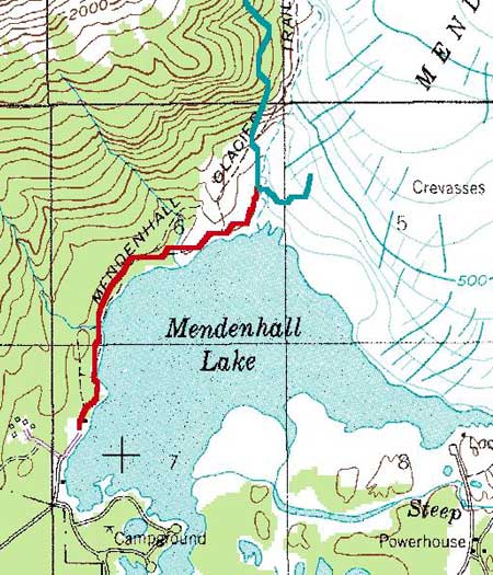
You will start your 5-6 hour trip at the back of a parking lot down off of Mendenhall Campground road. You can find this road off of Montana Creek Road. The beginning of the trail hugs the edge of Mendenhall Lake. The first quarter of a mile seems to have no real elevation gain and is basically a walk through the Tongass National Forest. You then start gaining elevation while still remaining within a 1000 feet of the lake, it’s just now you’re above the lake. Sometimes the trail can get discouraging with forest blocking what would be incredible views, but every now and then you get some breaks that allow for great pictures. Nice little “creek falls” also dot this trial, and allow for a quick cool down spot.
The last quarter mile of the trail is much like the first quarter mile, with a nice flat stretch crossing two creeks. Where the trail ends is hard to say, it’s more like the trail turns into two separate trails. If you go up the rocky mountain then you are taking off on the McGuinnis Mountain Trail (which has no beer on it), down will lead you on an unnamed trail to the glacier. Please read the safety section of this review to fully appreciate how much more dangerous both these trails are.
Important Information
In the 4 years of hiking in Alaska I have never startled a bear; on this trail I did. I should have known to turn around when I saw the fresh bear scat on the trail. In being the amateur Alaskan I was, I didn’t think anything of it. But coming back from the summit, right after the creeks, there was a young brown bear 60 ft in front of me sitting on the trail. It was very young, maybe 2 years old, and ran up into the woods before I could even start to scare it off. The lesson to learn here is to know the warning signs Mother Nature puts out there. It was no mistake that the bear left the scat right on the trail, he/she was trying to tell us that we should watch out. Don’t let this discourage you from trying the trail; just don’t make the mistake I made.
If you start up McGuinnis Trail know that it gets very rocky and the trail hugs some very steep cliffs. It is also very difficult to locate so make sure you take some mental notes and know how to get back to West Glacier Trail. I have never taken the unmarked trail that leads down to the glacier but from what I understand it too is fairly dangerous. I hear it involves some bushwhacking and climbing equipment. Do some research before you attempt to try either of these trails.
The following was added by the webmaster September 29, 2008:
Came down for a 4 day weekend to Juneau and hiked this trail. To add to the comments above; the last 1/2 mile is full of boulders that you must scramble upon and can be quite slippery in the rain. Take your time and be careful! Once you get out of the trees to the scraped glacial rock, getting to the actual glacier is easy if you follow the cairns.
This is definitely a destination, not the journey, hike as most of the trail is under canopy.
Etc.
People pay $200 to fly onto and around the ice field via helicopter! $10 in water and trail mix will get you there just as well as any Sikorsky can. So remember, you're not spending 6 hours; you're saving $190.
Don't have the 6 hours to take this trail? No problem, simple check out the East Glacier Trail on the other side of Mendenhall Lake. At only 3 hours it is a pretty similar trail except the ice field is not as visible.
Photos


Finding the Trailhead
Hike Map