Gold Mint Trail
Matanuska ValleyDescription
This is a pretty cool trail. At first I gave it 3 hooves but then I started really remembering this hike. It had been over 2 yrs (I did it in 2000 - wrote this in 2002) and I had to remind myself of all the cool sites that I saw on this trip.
The Little Susitna River (which some people call this trail) is a beautiful glacial river and the trail pretty much follows it along a narrow glacial valley with plenty of great waterfalls, especially at the end. The vegetation is lush but the little bushwhacking you may have to do is not overly annoying.
When you get to the end of the valley, you'll head up the mountain and that's when the real fun begins. The hanging valley on top is a floor of incredible greenery with the river cascading down and thick patches of snow (even in August!). This floor is ringed by a circle of jagged peaks and boulders that are just begging to be explored. Set up camp and oblige them their request. Use your topo map to get to Mint Glacier and its tarn. The next time I do this hike, I plan on getting there one day, day hiking all around the next, and heading out the day after that.
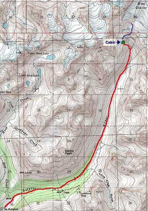
There is a hut run by the Alaska Mountaineering Club that is surprisingly well equipped. The rental fee is membership in their club, an incredible bargain at $15. Membership application, etc. is on their website. They ask that you replace their cooking oil (so why don't you just bring your own), keep the door locked from bears, and of course, don't take anything and don't screw with anything. When I did this hike in September 2000, it was rainy and cold and I sure was glad to be able to crash there.
2 really cool things happened when I did this hike. One was that while I was in the hut making dinner, the valley filled up with fog so fast that all I could see were the peaks when I came back outside. The other was during the next morning when I was sitting on the stoop of the hut sipping my coffee and two hoary marmots sat on a boulder close by watching me and chattering away. Go to the photos page for visuals on these.
The following was added June 6, 2009:
After 9 years, I finally re-did this hike as a day trip. Like the woman below, I was headed to Reed Lakes but the road was closed.
A lot has changed since 2000. The parking lot is much bigger with picnic tables and fire pits (not sure if it's ok to camp). The trail has really been worked on and the first 2 miles would be very doable for someone in a wheelchair or pushing a stroller. There are mile markers for the first 5 miles (I can't remember if these were always here).
And boy! The woman below is not kidding about the beavers. They have really called this place their own.
Anyway, I still believe this is a great trail. The "little Su" has to be one of the most gorgeous rivers in the world, seriously! This is one of the nicest glacial valley's in Alaska and I need to hike this more than every 9 years. I still plan this season to overnight up at or near the hut and then explore the glacier the next day.
Important Information
About 1/2 way there you'll have to ford a narrow but very deep tributary coming down the mountain. You can look around for a better place to cross but you might as well take your boots off (or not), and just do it. Added by the webmaster in 2009: it looks like some trail work has been done so you can boulder hop but if it's been really raining, you'll still probably get your feet wet.
Be prepared for rain and cold. If it's raining you will get soaked bushwhacking through the willow if you aren't well protected. Added by the webmaster in 2009: I wrote this when I went in September, 2000. In June of 2009, it was very clear and not a problem. I'm not sure if this was due to trail work or just that the shrubs haven't had time to grow.
Bring a walking stick as the ridges can be slippery and sometimes icy. Needless to say, be very careful and only handle what you have the experience to handle.
There are not too many sites to set up camp; do a little planning ahead use the hut. If you go during a weekday, you'll have a better chance of insuring a space.
There are no official trail maps of the area. You will need to buy a topo map (USGS Anchorage D). A list of stores in Anchorage that sell them can be found on the Education page.
Etc.
The parking fee is $5 (bring exact amount). The price for an annual parking pass is $60. You can purchase a pass at the Federal Building at 4th and F or the Atwood Building on 7th and E, 13th Floor.
This hike is in the Hatcher Pass area. Heading up the road to go over the Pass is worth the time after you're finished hiking.
The best way to hike this in the winter is to buy a cheap plastic sled and carry your stuff on it. For details about how I built mine, go here.
- Special section on alternate route to Reed Lake - Mint Valley to Reed Lake
- Special section on Mint Bomber Traverse
Photos


Finding the Trailhead
Hike Map